

A Night View of Abbottabad City

Another Beautiful View of Abbottabad City at Night with Snow Covered Mountains at the Background

An Aerial view of Abbottabad City and Valley

Another Aerial View of Abbottabad Valley

Pakistan Military Academy, Kakul, Abbottaba

Passing Out Parade at PMA, Kakul, Abbottabad

PMA Gymnasium, Kakul, Abbottabad

A Road in Abbottabad

Hill Behind Baloch Centre, Abbottabad. The slogan “Ghazi ya Shaheed, Home of Balochis” written on the hill.

Ilyasi Mosque, Abbottabad. Ilyasi Mosque was built in 1932 on a natural spring. It was initially built on a smaller piece of land but now it is spread over five kanals. People throng this historical mosque to see its beautiful structure, drink the water of the stream and enjoy the yummy pakoras and tasty fish from a nearby hotel. This place has become a sort of picnic spot for the locals and the visitors from other cities.

Natural Fountain of Ilyasi Mosque, Abbottabad. This is the Natural Fountain of Ilyasi Masjid. Back in the 1960s it was a natural pool which had lot of fish.

Panoramic View of Ilyasi Mosque, Abbottabad

An Old Photo of Ilyasi Mosque, Nawan Shehr, Abbottabad

Mona Lisa Restaurant, Abbottabad

Commissioner’s House, Abbottabad

Town Hall, inside Municipal Gardens, Abbottabad

Jalal Baba Auditorium. Jalal Baba auditorium, located in the cantonment area of Abbottabad, was built in 1993. The building complex consists of an auditorium that can hold up to 500-700 people, a public library, Abbasin Arts Council, Abbottabad Development Authority, a computer literacy department and a National Book Foundation Centre. It also has a Karate Club.

Ghora Chowk (Horse Intersection), Abbottabad

Abbottabad Cricket Ground

Pakistan Uzbekistan Friendship House, Prince Bokhara’s Palace, Abbottabad

Saint Luke’s Church, Abbottabad

Another Photo of Saint Luke’s Church, Abbottabad

Swiss Villa of the pastor of Saint Luke’s Church, Abbottabad. This Swiss Villa was built in 1860. One can also see the endangered Labanese cedar trees in the photo.

Historic Villa of Sahibzada Abdul Qayyum Sahib, near District Jail, Abbottabad. Photo by Environmentalist.

Front View of District Jail, Abbottabad. Photo by Environmentalist.

19th Century Bungalow of Civil Surgeon of Hazara, Civil Lines, Abbottabad. Please see black stone masonry, lime mortar, bay windows, dormer windows, unique roof and chiseled stone chimney of this old building. Works Department had declared it “dangerous” since many years and it must have been demolished by now. Photo by Environmentalist.

U.S. Helicopter in Osama Bin Laden’s Compound, Abbottabad
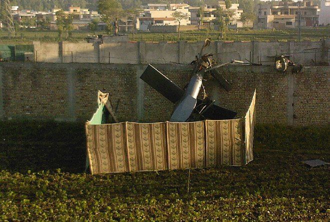
Osama Bin laden Compound, Abbottabad–02 May 2011

Ayub Medical College, Abbottabad

Garden of Ayub Medical Complex, Abbottabad

Frontier Medical College, Abbottabad

Army Burn Hall College for Boys, Abbottabad

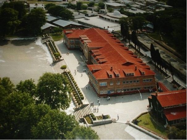
An Aerial View of Army Burn Hall College for Boys, Abbottabad
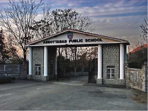
Abbottabad Public School
BISE (Board of Intermediate and Secondary Education), Abbottabad

Pine Hills Public School

Forest Rest House at Thandiani, Abbottabad. Photo by SaffyH – Uploading Iceland Photo’s. Thandiani, a hill station (Height: about 9000 feet), is located 31 kilometres from Abbottabad city. Here a Sanatorium and various other facilities were set up during the British rule, mostly for the convenience of missionaries, Anglican church personnel and officers stationed at Abbottabad cantonment. It also contained some private European houses, a camping ground, a small bazaar, and the small church of St Xavier.

Saint Xavier Church, Thandiani, Abbottabad, Pakistan

Dilapidated Condition of Saint Xavier Church at Thandiani, Abbottabad

A Bridge near Havelian, Abbottabad

Abbottabad in 1970. Tonga going towards Mona Lisa Restaurant and Lady Gordon’s Garden. Just observe that there are no vehicles on the road and the clump of trees have lined the road. Photo taken from outside the MES Office. Photo by Environmentalist.

Polo Ground of FF Regiment at Abbottabad, 1938

An Old Photo of Cantt Bazar, Abbottabad

An Old Photo of Abbottabad – 1930. Photo by Environmentalist.

An Old Photo of Abbottabad City, 1880-90

Another Old Photo of Abbottabad

An old View of Abbottabad, 1892

A Bungalow at Abbottabad in 1880s. Photo by richardasplen.

A Very Rare Photo of Abbottabad

Rare Photo of Main Bazar, Abbottabad in 1875

An English Bungalow at Abbottabad, 1875

General View of Abbottabad Valley in 1860s

Sketch of Abbottabad Valley – 1860s. It is the sketch of above photo.

Captain Mackenzie’s House at Abbottabad- 1865

An Rare photo of Abbottabad in 1863

Can you post more photos of old abbottabad ???
ReplyDelete